Sunday 26 October 2008

San Carlos to La Paz

Hola...As reported earlier, Hurricane Norbert was a non-event for us and we have since learned the lore that the force of the storm is in direct proportion to the amount of preparation you do - luckily we did lots - it took us a full day afterwards to set the boat back up. What did happen, though is that we had north winds that blew gusting over 30 knots for the next few days, so we had a delayed departure from San Carlos. Our forward hatch also broke when the wind smacked it against the deck...another item to add to our shopping list!


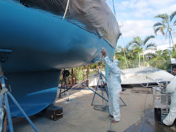
Lots of laughs with Bill....he kept us in stitches with his many stories. We've been out of internet range for the past two weeks, hence the lack of the weekly update. We enjoyed lots of new remote anchorages on our way heading back south. We are currently in the La Paz marina for a week, to do repairs, maintenance, etc. Unfortunately I'm not being as useful as I could be due to doing something stupid. While in San Carlos, I was in a huff with Peter about something, so I jumped off the boat, didn't look where I was going and landed on a cleat - twisting my ankle and wrenching my foot. I've been hobbling around for almost two weeks, so Peter dragged me to the x-ray clinic yesterday. The good news is it isn't broken , just badly sprained and swollen- I was pretty choked about the possibility of leaving Mexico on crutches as I had come in because of my knee operation. If all goes well, I should be able to ski when we get to Silver Star.

We did lots of fishing and have been lucky with Dorado (oh, Peter says it isn't luck!).


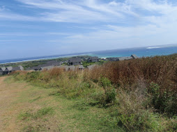
So I promise these are my last sunrise pictures until next year....but you have to agree that this is the magical time of the morning...Nothing feeds the soul more than an awe-inspiring sunrise.


One of the enhancements we have added to the boat (thanks to Bill for bringing it down from San Diego) is a self-steering windvane.


What this little gadget does is provide self-steering, so that while you are undersail, it will steer the boat (with supervision)....we are almost ready for our long passages next spring/summer/fall....some as long as 30 days of 24/7 sailing in the open ocean (gulp!).
We will be leaving La Paz on October 29th, with our two friends Bob and Liz whom we met when we went to their ranch for a 5 day outback horse trek. Our arrival in Mazatlan is expected to be November 1st if the winds cooperate and the crossing goes well. I'll check in again then.
Until next time....Happy Halloween and thanks for dropping by....can't believe we've had over 1,000 visitors to this site...hope I haven't bored any of you to death.

Monday 13 October 2008

We dodged a bullet!

It is now Sunday morning - a calm, beautiful morning with a clear sky full of twinkling stars. Hurricane Norbert decided at the last minute not to come visit us and I must admit not being sorry to be stood up this time.

It was almost like the Twilight Zone around here - the forecast called for 100% rain probability and we were expecting torrential rain with upwards of 10 inches with flash flooding and surge waves. (La Paz got 8 inches in less than 2 hours). We, however, didn't have a sprinkle of rain. There was not even a whisper of wind - it remained a steady 86% with 87% humidity well into the night. The only effect that we had at all, was some surging - however, Peter had us secured so well that we barely felt any motion.

So Hurricane Norbert was one big non-event for us here. It took us 2 days to strip and prepare the boat and probably will take a us a day to put it back together. Very good practice though and certainly better safe than sorry.

Tropical Storm Odile is also winding down as we speak, so looks like we'll have clear weather ahead for the foreseeable future. We will most likely cast off tomorrow and start slowly making our way over to La Paz, where we will spend a week and pick up friends for our final crossing of the Sea to Mazatlan, where we will be leaving the boat for the winter. We fly home (via Toronto for a week) on November 7th.

Thanks to everyone for your concern and emails. We are truly grateful to have all of you in our lives on this Thanksgiving weekend!

I'll update the blog in another week. Until next time...."I see my path, but I don't know where it leads. Not knowing where I'm going is what inspires me to travel it" Rosalia de Castro

Sunday 12 October 2008

Today is the day!

Good morning. Well, the 5:00 a.m. report has now extended the Hurricane Watch to northwest Mexico (where we are). This is the part of the update that applies to us...We are 17 miles north of Guaymas.


NATIONAL HURRICANE CENTER MIAMI FL EP152008500 AM PDT SAT OCT 11 2008... A HURRICANE WARNING IS ALSO IN EFFECT FOR THE COAST OF MAINLAND MEXICO FROM TOPOLOBAMPO NORTHWARD TO GUAYMAS. PREPARATIONS TO PROTECT LIFE AND PROPERTY IN THE HURRICANE WARNING AREAS SHOULD BE RUSHED TO COMPLETION.
Our area is now in the "red" zone...


The hurricane is expected to make landfall on our coast at about 9:00 p.m. so we have the remainder of the day to take additional precautions by stripping most of the boat and giving a hand to anyone else who might need it.
So, we'll just hang on for the ride and hope for the best. Unless there is some drastic change today I won't update until AFTER the hurricane tomorrow...assuming that we still have power/internet or phone connection, which is actually quite unlikely, now that I think about it. So, if you don't hear from us PLEASE DO NOT WORRY. (Remember worry is like a rocking chair - it gives you something to do but doesn't get you anywhere). We will be in contact as soon as we can be.


Wishing everyone a Happy Thanksgiving weekend.

Saturday 11 October 2008

Update at 2:00 p.m. October 10th

Well, it is getting closer and our area has been upgraded to a "watch" from a warning. We are in San Carlos, which is 17 miles away from Guaymas. Should be quite the ride!


This is a satellite image of Tropical Storm Odile and Hurricane Norbert


From the National Hurricane Centre..
200 PM PDT FRI OCT 10 2008...NORBERT STRONGER STILL...NEW WARNINGS ISSUED FOR THE COAST OFMAINLAND MEXICO...AT 2 PM PDT...2100 UTC...THE GOVERNMENT OF MEXICO HAS CHANGED THETROPICAL STORM WATCH FOR THE COAST OF MAINLAND MEXICO FROMTOPOLOBAMPO NORTHWARD TO GUAYMAS TO A TROPICAL STORM WARNING AND AHURRICANE WATCH. A TROPICAL STORM WARNING AND A HURRICANE WATCHARE NOW IN EFFECT FOR THE COAST OF MAINLAND MEXICO FROM TOPOLOBAMPONORTHWARD TO GUAYMAS.

The new photo of the "watch areas" follows: (we've gone from yellow to blue)


Hurricane Norbert - due to hit tomorrow - Oct. 11th

Pasted from the National Hurricane Centre website……

...NORBERT STRENGTHENS AND HAS BEEN UPGRADED TO A CATEGORY II AS OF 0800 FRIDAY, OCTOBER 10th

AT 2 AM PDT...0900 UTC...THE GOVERNMENT OF MEXICO HAS ISSUED A HURRICANE WARNING FOR THE WEST COAST OF BAJA CALIFORNIA SUR FROM PUNTA ANDRESITO TO AGUA BLANCA. A HURRICANE WARNING MEANS THAT HURRICANE CONDITIONS ARE EXPECTED WITHIN THE WARNING AREA WITHIN THE NEXT 24 HOURS. PREPARATIONS TO PROTECT LIFE AND PROPERTY SHOULD BE RUSHED TO COMPLETION.A HURRICANE WATCH REMAINS IN EFFECT FOR THE WEST COAST OF BAJA CALIFORNIA SUR FROM SOUTH OF AGUA BLANCA SOUTHWARD TO CABO SAN LUCAS AND NORTHWARD AROUND THE PENINSULA TO LORETO. A HURRICANE WATCH MEANS THAT HURRICANE CONDITIONS ARE POSSIBLE WITHIN THE WATCH AREA...GENERALLY WITHIN 36 HOURS.


NORBERT IS MOVING TOWARD THE NORTH NEAR 10 MPH..17 KM/HR. A TURN TOWARD THE NORTH-NORTHEAST WITH AN INCREASE IN FORWARD SPEED IS EXPECTED TONIGHT. A FASTER MOTION TOWARDS THE NORTHEAST IS EXPECTED ON SATURDAY. ON THIS TRACK...THE CENTER OF NORBERT WILLBE NEARING THE SOUTHERN BAJA CALIFORNIA PENINSULA SATURDAY MORNING. MAXIMUM SUSTAINED WINDS HAVE INCREASED TO NEAR 100 MPH...160KM/HR...WITH HIGHER GUSTS. NORBERT IS NOW A CATEGORY TWO HURRICANEON THE SAFFIR-SIMPSON SCALE. SOME WEAKENING IS FORECAST DURING THENEXT 24 HOURS BEFORE NORBERT REACHES THE BAJA CALIFORNIA COAST. ANAIR FORCE RESERVE HURRICANE HUNTER AIRCRAFT IS SCHEDULED TOINVESTIGATE NORBERT AROUND MIDDAY. HURRICANE FORCE WINDS EXTEND OUTWARD UP TO 35 MILES...55 KM...FROMTHE CENTER...AND TROPICAL STORM FORCE WINDS EXTEND OUTWARD UP TO 140MILES...220 KM.


NORBERT IS EXPECTED TO PRODUCE RAINFALL ACCUMULATIONS OF 4 TO 6INCHES OVER SOUTHERN BAJA CALIFORNIA AS WELL AS PORTIONS OFNORTHWESTERN MEXICO...WITH POSSIBLE ISOLATED AMOUNTS OF 10 INCHES. THESE RAINS COULD RESULT IN LIFE-THREATENING FLASH FLOODS AND MUDSLIDES. STORM SURGE FLOODING OF 2 TO 5 FEET ABOVE NORMAL TIDE LEVELS...ALONG WITH LARGE AND DANGEROUS BATTERING WAVES...IS EXPECTED ALONG THEWEST COAST OF THE SOUTHERN BAJA PENINSULA NEAR AND TO THE SOUTHEASTOF WHERE NORBERT MAKES LANDFALL. REPEATING THE 800 AM PDT POSITION...20.6 N...113.4 W. MOVEMENTTOWARD...NORTH NEAR 10 MPH. MAXIMUM SUSTAINED WINDS...100 MPH.MINIMUM CENTRAL PRESSURE...973 MB.


AN INTERMEDIATE ADVISORY WILL BE ISSUED BY THE NATIONAL HURRICANECENTER AT 1100 AM PDT FOLLOWED BY THE NEXT COMPLETE ADVISORY AT 200PM PDT.


Here is a picture of the Hurricane Tracking…We are located on the mainland coast on the right hand side – right along the current track (although nicely secured). We are in the yellow zone. This will change as the hurricane makes the first landfall on the Baja Peninsula and moves across towards us.


Locally, San Carlos is abuzz – the port Captain has CLOSED the port of Guaymas (about 20 miles from us) and this weekend’s annual Billfish Tournament which takes place at our marina has been cancelled.

At this same time, another Tropical Storm Odile – pronounced Oh-Deal (where the heck do they get these names??) is building and will also affect the Baja, so we’ll all be watching this one closely as well.

So, we have battened down the hatches and will keep our heads down!

Until next time….Happy Thanksgiving weekend (and Happy Birthday to my nephew Matt).

Friday 10 October 2008

Hurrican Norbert, a Pacific Gale and a Tropical Storm, oh my!

Good morning. We are going to have some interesting weather this weekend. Hurricane Norbert is expected to make landfall somewhere around here - within 100 miles give or take. It will be the second landfall, so the winds are expected to be significantly less than when it makes landfall in California - possibly 60 miles an hour plus torrential downpours.

In addition there is currently a Gale coming down the Western Coast (Oregon/California) and these two systems are expected to do some dancing when they join forces. Right now there are already 28 foot waves off the coast in California, so things should get pretty nasty there.

Just this morning, there is now a new Tropical Storm (Odile) that has formed and is coming up this way - possibly to make landfall on Tuesday. Not sure yet which way it is tracking and where the landfall will be at this point. The focus remains on Norbert at this time.

We have decided to hunker down in a slip at the San Carlos Marina. These are brand new docks and we have a slip between 2 multi-million dollar/2 story 65 foot power boats, with full-time crews aboard. We feel rather dwarfed, but also feel snug as a bug in a rug. As I type this, Peter is out retying lines, adding lines, etc., etc.

Last night Peter was the ham net operator and he had over 18 check-ins including some boats in some dangerous places. Lots are making a run from wherever they are. Most of the gang up here have headed for one of the three "hurricane holes" - San Carlos Marina being one of them.

Our good buddy Bill has just arrived from Powell River. He brought down our brand new self steering system and a new barbeque. He will be working on his boat for the next month but they are not bringing it out of storage to the work yard until this Hurricane passes over...so for the next couple of days we'll be having some fun with Bill.

Until next time......Yesterday is a cancelled cheque, tomorrow is only a promissory note...today is cash in hand. Spend it well.

Thursday 9 October 2008

Hurricane Norbert - special posting


Good morning everyone. We've received quite a few "concerned" e-mails about Hurricane Norbert which is expected to make landfall on Saturday so thought I'd do a special posting about it.


Yes, it is headed our way and yes, we are making plans to hopefully stay out of its' way as much as we can. We appreciate all your concern - we are feeling loved! We were planning on staying in San Carlos to meet a friend from Canada to go out sailing for a few days, but out here in the sea all itineraries are written at low tide. After getting a few more weather updates today we will make our final plans as to where we will "wait out the hurricane". We are taking this one very, very seriously and will make plans accordingly - so rest assured that we may be adventurous, but we aren't reckless.
We are looking forward to spending our winter in Silver Star in another month and seeing the kids and friends. Here's a great shot from this weekend of Danny and Kylie at the Toby Keith concert in Kamloops...it's great they get along so well.


Direct from the Hurricane Centre - October 8th


10/08/08 3AM MDT FROM THE NHC...NORBERT BECOMES A MAJOR HURRICANE WITH 115 MPH WINDS... INTERESTS IN THE SOUTHERN BAJA CALIFORNIA PENINSULA SHOULD MONITOR THE PROGRESS OF NORBERT.
FOR STORM INFORMATION SPECIFIC TO YOUR AREA...INCLUDING POSSIBLE INLAND WATCHES AND WARNINGS... PLEASE MONITOR PRODUCTS ISSUED BY YOUR LOCAL WEATHER OFFICE.

10/08/2008 5:37 AM MDT Hurricane Norbert continues to strengthen and is now a Major Hurricane some 470 miles south of Cabo San Lucas. Currently a Category 3 Hurricane, Norbert is expected to strengthen to Category 4 in the next 12-24hrs. Forecasts call for Norbert to lose some of that intensity before making landfall near Magdalena Bay late Friday or early Saturday.
Hurricane Norbert is currently located near near 16.1N 110.0W and motion is 295° at 9kts. Central barometric pressure is estimated at 960Mb and winds are 100kts with gusts to 120kts. Norbert is forecast to turn more northward in the next 24hrs and is expected to make landfall as a strong Category 2 intensity hurricane near Magdelena Bay on the Pacific Coast of Baja California Sur. Wind speeds at the time of landfall are forecast to be in excess of 95kts.
Persons with interests in Baja California Sur should begin preparations for a hurricane landfall and significant wind and rain conditions which could begin as early as late Thursday. All of Baja Sur is still within the 5 day forecast threat window. Those along the Pacific coast of Baja California Sur should pay particularly close attention to the path of this storm over the next 24-36hrs.
Hurricane force winds will extent out approximately 65 miles and tropical storm force winds are forecast to extend out as much as120 miles from the eye at the time of landfall. Heavy rain and the potential for flash flooding will be a possibility across the entire state of Baja California Sur through the weekend.
Hurricane Norbert now has a clearly defined eye as it begins to turn to the north, and will remain over +28°C water with optimal conditions for continued development for the next 36hrs. Norbert is now a Major Hurricane, a hurricane of Category 3 or more is considered a Major Hurricane.
Norbert is forecast to continue strengthening and should surpass Hurricane Hernan as the most powerful storm of the 2008 Hurricane Season later today. Hernan formed in the first week of August and moved off into the Pacific without ever making landfall with maximum winds of 105kts. Norbert is forecast to achieve maximum sustained winds of 115kts and gusts to 145kts or 160 miles per hour.
Although Norbert is forecast to diminish to a Category 2 Hurricane before making landfall it could be be one of the most powerful hurricanes to hit Baja since Hurricane John in 2006. Due to the fact that it will make landfall directly off the Pacific Ocean storm surge, or the water pushed ahead of the storm, could be more significant than storms of the past few years.
The storm track is currently predicted to cross the peninsula into the Sea of Cortez near Loreto and Mulege. Those areas should prepare for the likelihood of significant rain and the potential of severe flooding should the storm hold to the current track.
Norbert is remaining very close to early path projections, bending ever more to a NNE track in the next 36hrs, Current projections have a Hurricane Norbert several hundred miles WSW of Cabo San Lucas on Friday morning as a Category 4 hurricane.
Only one major Hurricane has ever made landfall in Baja California Sur in the last 50 years and that was Hurricane Kiko in 1989 which came ashore on the East Cape, when the area was much less inhabited than today.
Also, keep in mind that intensity forecasts are the most difficult when attempting to predict a hurricane's behavior. Hurricane John in 2006 was forecast to make Baja landfall as a Major Hurricane yet diminished to a Category 2 before making landfall in the East Cape region.
The next update to this information will occur following the 3PM release

Sunday 5 October 2008

Net Controller's Party & Running out of fuel

The cruising life.....

e
The mountains at sunrise yes, that is Di knitting at the helm
The water clarity is starting to improve dramatically – it is as clear as it was in the Spring. We’ve been doing lots of snorkelling (Peter got an ear infection, but a week of antibiotic drops seem to have done the trick).

Hundreds and hundreds of dolphins while underway

We went to an anchorage that definitely is on my top ten list called Salsipedes. It is actually two islands connected by a small bar/beach. Unlike most of the islands, which have loose, shale rock, this one has solid rock, which makes for ideal hiking.

the Islands of Salsipedes
It also has a high peak on it, so needless to say we made our way to the top, which was exciting and edgy. Peter says he earned extra beer rations again that day!

sharing this anchorage with only the Pelicans and the sea lions

After a few days out in these anchorages we went to Puerto Don Juan – also known locally as Puerto Pollo (chicken), as it is the hurricane hole up in the northern Sea of Cortez. We were invited onboard for mango margaritas by Dave and Marcia of Juniata where we had a great time.

Coyotes on the beach out walking with the birds

The next day over 10 boats gathered in the Bay of L.A. for the annual ham radio net controllers party – of which Peter is one. To make things interesting, the seas whipped up with gusting winds of 25 plus knots. Some of the boats decided to head for calmer anchorages and others decided to stay on board to keep a lookout while the rest of us had some rough dinghy landings. A good time was had by all at the beach papapa of our hosts Jay and Janis of Ceilidh. Peter won the dart tournament, so he was harder to live with than ever after that!


Is this not a picture perfect anchorage???
We left bright and early the next day – heading back on our southbound journey. Fortunately, there are so many anchorages, they will all be new ones for us to explore. We stayed for a couple of nights at a spectacular anchorage - one of the top two so far – really! Los Animas Slot. The snorkelling was outstanding and the hiking excellent – plus we were snug as a bug in the tiny cove.

Animas Slot from atop the hill

The final leg to Santa Rosalia (the first town with a bank in over 6 weeks) was a 77-mile stretch. We got up at 0300 and motored all day. Had a bit of excitement when we were only 2 miles from the harbour entrance we ran out of fuel!!!! Peter hopped in the dinghy and took a jerry can, while I stayed on the “dead” boat. There was hardly any wind but there was a strong current and a few pangas out fishing. I was a nervous wreck, but did manage to tack with just the main sail before hitting any boats or the beach. Peter borrowed $20 from a friend in the marina so that he didn’t have to get to a bank first and was able to make it back to me within an hour.

too bad about the crowds...
We will stay here for about 4 days to do some provisioning, maintenance on the boat and catch up on banking and with the kids. Next stop…San Carlos.

Until next time.... There is currently a Tropical Storm watch that we are keeping an eye on….could get interesting!

QuickStar

QuickStar
46 foot Beneteau

The journey begins.....

I update this blog every Friday, so that you can share in our adventure and learn about new places and cultures.

Only the most recent blog shows up on this page. To see former postings, please click on the Archives below.

Thanks for dropping in to visit. Hugs from Diana and Peter.